Welcome to Bidwell Lore number 167! We hope you had a wonderful Thanksgiving holiday with your family. As we near the end of our Agrippa story, we go this week to a post about Evergreen Hill in Stockbridge.
Visiting Evergreen Hill
Rick Wilcox, 2022
We will begin this installment of the Agrippa story by going back to 1818, when the Stockbridge Mohicans sold the last piece of their land in Stockbridge to David Goodrich. The deed reads as follows:
Know all Men by these Presents, That We Hendrick
Aupaumut, David Neshoonhuk, Solomon Z.
Hendrick, Abner W. Hendrick, Solomon W. Hendrick
Sachems & Counsellors of
the Muhheconneek tribe of Indians who formerly were
proprietors of the Town of Stockbridge in the county of
Berkshire & commonwealth of Massachusetts & some
years since removed there from & who now reside in
New Stockbridge in the state of New York. In consideration
of ten dollars paid by David Goodrich of Stockbridge
aforesaid Have & by these presents do for ourselves and
for our tribe remiss release & forever quit claim
unto the said David Goodrich a certain tract of land
lying in Stockbridge aforesaid containing by estimation
four acres it being part of a road formerly referred by the
said Indian proprietors to lead from Said Stockbridge to Sheffield
of an undescribed width, but afterwards surveyed out by order
of the county court of said Berkshire & consent of the
said proprietors & laid four rods in width, the part hereby con-
veyed is now by said court discontinued to wit beginning
at the South line of said Stockbridge & thence northerly as
said road was laid out as far as where Ichabod Fairman
lives – being about two hundred rods [1] – Against Said piece of
road grants [2] were formerly made & laid by the Said proprietors on the
west side of the same to Stephen Nash, David Pochause &
Joseph Woodbridge & on the East side to Ebenezer Poopoonuck,
Shuthoump & Timo Woodbridge as may appear by
said proprietors records. [3]– Referencing to said Town of Stockbridge
for the use & privilege of the said county of Berkshire free of
any future expense the whole of the said land, if the said
county ever in future, shall new lay a road over the
said ground. To have and to hold to him the said
David Goodrich his heirs & assigns forever & we hereby
for ourselves & our whole tribe covenant & engage
that neither We nor they, nor any other person or persons
from by or under us or them shall in any wise molest
or disturb him the said David Goodrich his heirs
or
or assigns in the possession or improvement of the Said
land & premises. In witness whereof we the said Sachems
have hereunto set our hands & seals the 29th day of
August Anno Dom 1818
Signed Sealed & delivered Hendrick Aupaumet} sachems
In the presence of us David his X mark Neshoonhuk
Rebecca Dean Solomon Z Hendrick} coun-
John Sergeant Abner W. Hendrick} ers
Solomon W. Hendrick
State of New York Oneida county SS September 5th 1818
Personally appeared Hendrick Aupaumet
David Neshoonhuk Abner W. Hendrick &
Signers & sealers of the foregoing instrument
& acknowledged the same to be their free act
And deed before me
Elisha Pettibone Justice of the peace [4]
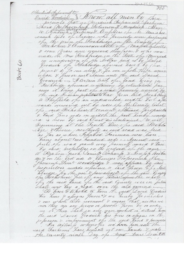
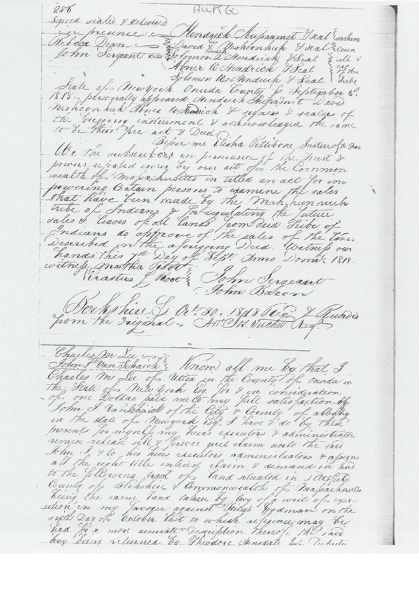
Copy of Deed Book 60, Pages 255 and 256 from Berkshire Middle Registry of Deeds, Pittsfield

As you may remember from earlier in the series, the land referenced in the Deed above had been granted to Joab Benney in the mid-18th century when he came to the Berkshires from Northampton, bringing along a young Agrippa Hull. With Josh Hall, from the Stockbridge Library Museum & Archives and a longtime resident of Clark Road, acting as a guide, we traversed almost all of Evergreen Hill between the end of Clark Road and the Great Barrington line, hoping to locate some evidence of the home lot of Joab Benney, whose 50 acres bordered the road to Sheffield and then went east until it came to Taupaugoh brook, now referred to as Konkapot Brook and also Peggy’s Brook. There was also the tug of walking on land that was the last piece of Mohican land in Stockbridge to be sold. Although there were a number of large red oak trees, the hill was, for the most part, covered with a variety pioneer tree species. It would be hard to know what type of evergreen trees covered the hill that gave it its name. For Joab Benney to conduct a tanning business, he would have needed hemlock trees. At the time he purchased land in Stockbridge, it would be safe to assume his fifty acres were covered with mature hemlocks. The other climax species in the Berkshires is beech, which Benney would have avoided. Agrippa Hull likely spent a great deal of his childhood on Evergreen Hill and walking there feels like a walk back in time.

Next week we will discuss a bit more about Margaret (Peggy) Hull.
1. 3,300 feet or 0.625 miles. Roughly from the Great Barrington line to the last house on Clark Road.
2. The Indian Proprietor Records does not show any land grants for roads in Stockbridge. If they did in fact grant land for roads, it might account for some of the “missing” 8,600 acres not found in deeds.
3. North from the town line over Evergreen Hill to Clark Road ending at Goodrich and Cherry Hill Road.
4. Berkshire Middle Registry of Deeds, Book 60, Page 255 (1818).