Welcome to week 48 of Bidwell Lore! This week we finish our story about the three Meeting Houses of Stockbridge and learn about a Mohican Burial ground discovered during the building of the second Meeting House.
In part 1 of this article, we discussed the strategies around the building of the first and third Meeting Houses in Stockbridge. This week we are going to focus on the second Meeting House, built in 1784.
This story begins 18 years before, when the first Meeting House was 27 years old. In 1766 James Willson transferred to his son Elijah Willson “in Consideration of Divers good causes me thereunto moving & before the Ensealing hereof Especially the love I bear to my Son Elijah Willson one certain Tract or Parcel of Land lying & being situate in the Township of said Stockbridge & is butted & bounded as follows (VIZ) Eastwardly by land formerly belonging to Ephraim Brown now belonging to the Said James Willson & Northwardly Westwardly & Southwardly on Highways [1] which Land formerly belonged to Several Indians (VIZ) Cheeksunkun, Josiah Mhuttauwu & widow Yokum [2] & lies between the highway that leads from Meeting House & said lot originally Laid out to Ephraim Brown aforesaid on which the said James lives containing by Estimation Twenty five Acres be it more or less. [3] All mines Minerals that may or Shall be found in that part of the Premises that belonged to Cheeksunkun. (Twenty-five Acres)”
Then on July 5th, 1766, Elizabeth Pahtecooquoh sold “five acres of land in said Stockbridge be it more or less bounded as follows viz Westerly on the highway by northward, by Eastwardly, & Southerly on said Wilson’s own land,” for twenty pounds to James Willson. North of Elizabeth’s land had been the property of Jacob Cheeksaunkun [4] and on the west side of the road the settle lot of Kekhanhoots and below him the land and settle lot of John Wauwaumpequnaunt. [5] John’s lot went west to Chochechokeseepooto Brook [6] and was bordered on the north by a second lot belonging to Jacob Cheeksaunkun. Also northeast of John was a lot owned by Waunauhauqos. On the west side of the highway was a six-acre lot belonging to Abraham Nimham, [7] bordered on the south by Waumpnankusquoh, on the north by Daniel Wauwaupeeqweaut, and east on the highway leading to the meetinghouse, which was across the street.
From the Town Meeting Book 2, p 153, on November 8, 1781, we find the following entry about the best considered location for the Meeting House:
The committee appointed by your vote fifth of January 1782 to fix the plan for your meeting house met at Stockbridge the 27th day of August 1782 went and with your town committee and particularly viewed all parts of town the several roads – their centers – their assets and their points their qualities, the mountain pond, and morass the situation of the Inhabitants the parts that seem naturally formed to be annexed to the town and those that ought to be set off. And particularly attended to the three several places pointed out to us by your votes for the house – have heard and particularly attended to all the reasons and arguments laid before us by your committee and have seriously taken into consideration every other matter which we suppose can or probably will operate in the case – and we unitedly think that the best and most convenient place for the meeting house in the Town of Stockbridge is at Brown’s so called and we have set up the stake for the northeast corner of the house. We would likewise mention to you that we had in view the fitness that a part of Barrington should be annexed and the northeast corner set off – that in the situation of the town Browns appears to us to be the best place where the people can (all things considered) with the least trouble and greatest conveniency meet – and as you have called us to give our opinion in the matter – and the reasons (all things considered) in our view being so full for the above place – we most earnestly recommend it to you, unitedly to agree and to build in said place a decent and honorable house where you may with one heart and mind worship and serve the great God of Love & peace which will continue to characterize and distinguish this respectable people. All which is submitted to your candid judgment by your most obedient and humble servants: Timothy Robinson, William Williams, Nathan Hall, Committee, Aug 31, 1782.
Voted that the committee appointed to build the meeting house be directed and empowered to enter into a contract with Mr. Elanthan Higbee to erect and finish the meeting house.
1782 Silas Pepoon (Collector) to the Town of Stockbridge
May 13 To a rate committed to you to collect, agreeable to Votes & Grants of the Town
be L 39-1-11
May 18th to pay Rev West his all L 45-12-6
1783 March 14th To one agreeable to January Grants of the Town L 158-6-10
To one for support of the schools L 53-6-9
April 30, 1783:
To one for building a Meeting House L 200-4-10
To one to pay Rev Wests sal from June 13, 1782 to June 13, 1783: L 49-6-51
August 22 1783 to one for building a Meeting House L 218-17-5
To Misters Kirkland & Sergeants proportion towards building said House: L 13-19-8
To Meeting House Tax: L 138-4-9[9]
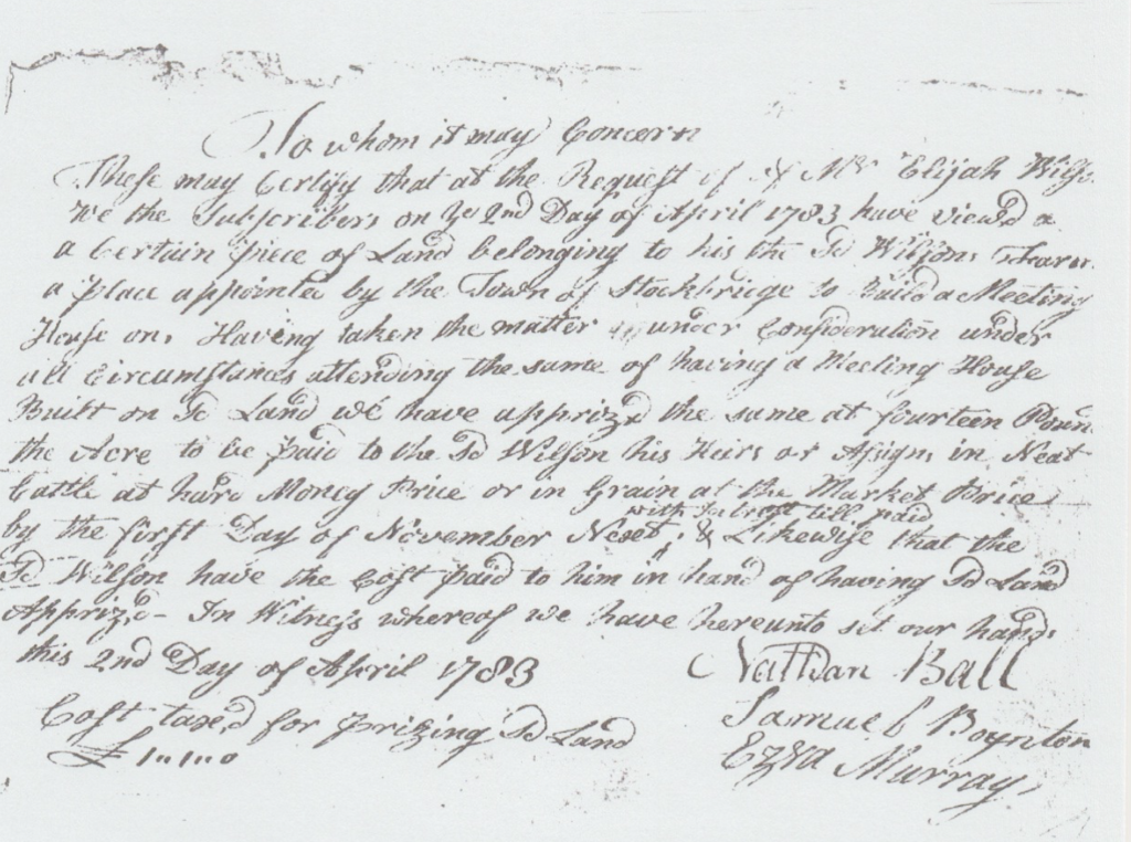
In 1783 the following document was created:
To Whom It May Concern: These may certify that at the request of Mr. Elijah Wilson we the subscribers on ye 2nd day of April 1783 have viewed a certain piece of land belonging to his the sd Wilson’s Farm a place appointed by the Town of Stockbridge to build a Meeting House on. Having taken the matter under consideration under the circumstances attending the same of having a Meeting House Built on the Land we have apprized the same at fourteen pounds the Acre to be paid to the sd Wilson his heirs or Assigns in Neat Cattle [8] at hard Money Price or in Grain at Market Price by the first Day of November Next with Interest till paid. & Likewise that the sd Wilson have the cost paid to him in hand of having sd land apprized – In Witness whereof we have hereunto set our hands this 2nd Day of April 1783 Nathan Ball, Samuel Boynton, Ezra Murray. Cost taxed for prizing sd land L I..I..0[10] Original document can be seen below.
On January 20, 1783, they (the two committees) voted that the town unite in building a Meeting House on high ground east of the house of Mr. Asa Bement and that 700 pounds be appropriated for that purpose. The house was to be fifty feet by sixty; the posts twenty-six feet long; and the steeple sixty-two feet high, erected at the east end of the house opposite the pulpit. The pews were to be square. Two hundred pounds was raised in early 1783, 14 pounds was collected for the completion of the steeple in September 1783, and in 1784 an additional 380 pounds was raised. On October 2, 1783, (Town Meeting Records Book 2, p 166) the town voted and granted the sum of two hundred pounds for the further finishing and accommodating the meeting house, with half to be paid in money and the other half in beef or grain. It was also voted that anyone who had professed a religion that was different from that generally professed by the inhabitants of the town, before the town voted to grant the additional two hundred pounds, would be discharged from their meeting house taxes by the town treasurer.
Another vote, in September 1784, gave to Dr. Oliver Partridge the liberty of erecting, at his own expense, a large pew over the entrance doors of the gallery, to be used by him as he pleased during his residence in town, except as much of it as should be occupied by the tithingman. On March 16, 1785, it was voted that horse sheds would be built over the ditch east of the meeting house, except against the east end of said house and fifteen feet north and fifteen south of said house. It was also decided that Asa Bement, Timothy Edwards, and John Bacon be a committee to direct each person were to build such sheds.
In 1785 the ground about the house was put in order, the sheds for horses built, and the house cleaned and doubtless dedicated. But the situation was found to be a bleak one. In May 1797, alterations and repairs were ordered, and again in 1804; besides internal repairs, it was voted as a measure of safety to reduce very much the height of the steeple.
“The lower part of the house was entered on three sides, aisles crossing each other at right angles; and another aisle ran quite around the house, within the wall pews. Over the pulpit was large roofed projection, like the frame work of a canopy, designed to reflect the sound from the high, old fashioned pulpit, upon the congregation below. The galleries turned at right angles, and were so deep that the back of the three parallel seats there was room for an aisle, and square pews. The communion table was half an ellipse; and when not in use, hung down from a breast-work in front of the pulpit. Behind the breast-work and almost beneath the pulpit, was the seat for the pastor and deacons. The house was white without, but excepting the “high pew” and the pulpit with its “sounding board,” all was unpainted within. No carpets, it is believed, were ever introduced, and even the comfort of a stove was for 30 years unknown; yet many happy hours were spent there, and many grateful thoughts will revert to that spot as the song of praise swells on to all eternity. When the ground was prepared to erect this church, many human bones were discovered, supposed to be those of Indians, over taken and slain here by Major Talcott in 1675.” [11]
To further explore the discovery of bones while building the Meeting House: “As early as the memorable war, called King Phillip’s war, about 200 fugitive Indians were observed to pass by Westfield, going westward; ‘News thereof (says Hubbard in his Narrative of the Indian Wars) being brought to Major Talcott, he with soldiers of Connecticut colony under his command, both Indian and English, pursued after them as far as Ausotunnoog (Housatonic) river (in the middle way betwixt Westfield, and the Dutch river and Fort Albany) where he overtook them, and fought with them; killing and taking 45 prisoners, 25 of whom were fighting men, without loss of any one of his company, save a Mohegan Indian: ….. This battle was probably fought in Stockbridge, near the site of the meeting-house erected in 1784, recently taken down. In removing the earth, to prepare for the foundation of the house, Indian bones were found, which may have been the bones of persons slain in the conflict.” [12]
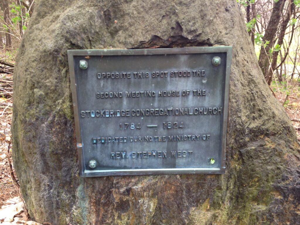
Grace Bidwell Wilcox, (1891-1968) who was Curator of the Stockbridge Library Historical Room from 1938 to 1968, in the 1950s offered words from a manuscript by Dr. Oliver Partridge that mentions bones found during the construction of the second meeting house in 1784: “finally we built on this place….very uneven on which were a number of little hillocks in leveling of which we plowed up the bones of 13 Indians who were probably some of the Nipnet and Pacomtuck Tribes whom Maj. Talcott and company pursued from Westfield and killed on this spot in 1676 – 120 years ago – see Hubbard’s Indian Wars.” [13]
Colonists, as they traveled over the Berkshire Hills from the Springfield area, often referred to the Berkshire Hills and the Housatonic River Valley as a howling wilderness. Therein suggesting that no people would be found living in this area and therefore felt no need to inquire about land ownership. Mohican sachems did manage to sell a majority of the land in Berkshire County to a number of English colonists as well as the provincial government; however, in the end, they were dispossessed of all their land in Berkshire County.
Oliver Partridge in his short history does not reveal what happened to the “bones of the 13 Indians,” leaving one to speculate on their fate. It seems likely given Dr. Partridge’s background and relationship with the Stockbridge Mohicans he would have worked with them to remove the remains and rebury them either in the Indian Burying Ground or in that section of the town cemetery where other Mohicans were buried. We can state with certainty that the remains are no longer at the second meeting house site as Stockbridge-Munsee Mohican Tribal Historic Preservation Officer Sherry White and I applied for a Community Preservation Grant to perform ground penetrating radar (GPR) on the property, which indicated no human remains were present. Given the considerable presence of burials and artifacts in Berkshire County, it seems reasonable to assume the remains of “13 Indians” was simply another Mohican burying ground and likely not a part of King Philip’s War.
In a Special Town Meeting on November 4, 1879, it was voted that the Town accept a deed of certain land adjacent to the Town Common, on the condition that the said land, together with the Town Common, shall be dedicated forever as a public park.
“To the Selectmen of the Town of Stockbridge, Mass. Wishing to do something for the improvement of my native town and the enjoyment of its people I make the following proposal.
If the Town will set apart, by a formal vote at the next Town Meeting, in such manner as shall be legal, so much of the land belonging to the Town situated on or adjoining the highway, about half a mile north of the Congregational Church, as formed the Old Meeting House Green together with the land between it and the highway; and if the acre and a half now belonging to Mr. John B. Hull, which formed a part of the same, can be obtained at reasonable terms, I will at my own expense cause the whole to be graded and planted with trees and laid out as a Town Park to be kept for the use and beauty as a pleasure ground for the people of Town forever. Yours faithfully, Cyrus W. Field.”
“Voted the following Resolutions: Resolved: That whereas Mr. Cyrus W. Field wished to do something for the improvement of his native Town and the enjoyment of its people that the deed presented to the Town be accepted and that the same with the adjacent Town Common be laid out, and dedicated as a Public Town Park forever in accordance with the proposal of Mr. Field and that the same be placed at the disposal of Mr. Field to improve and beautify as he may wish.
Resolved: That the Town tender to Mr. Field a hearty vote of thanks for his liberal proposal.
Resolved: That a survey be made of the premises and that a Record be made on the Town Records of the same and that a copy be recorded in the Registry of Deeds at Pittsfield.
Resolved: That the Town Clerk be instructed to forward to Mr. Field an attested copy of these instructions.”
However, at the Annual Meeting on April 5, 1880, it was voted that the Town Clerk return the deed of land given by Mr. John B. Hull for the public park. No explanation was given for the return of the land and Cyrus West, Field of Transatlantic Cable fame, seemed to have faded from view. Around that time, Field became involved with stock speculation and lost a great deal of money. In 1885 he moved back to Stockbridge, dying in 1892 at age 72. Coincidentally, the property that was first owned by Stockbridge Mohican Elizabeth Pohtecooquoh, then sold to James Wilson who then gave the land to his son Elijah Wilson, who later sold it to the Town of Stockbridge for the second meeting house which was then acquired by David Hull around 1825 from the Congregational Society, passed down to Hull’s son, John B. Hull (1835-1914) [14], and ultimately sold to Cyrus Field.
“This property was given to Laurel Hill by David Dudley Field on April 7, 1937 (475/425) [15] The land was sold by John B. Hull (1835-1914) to Cyrus Field on September 7, 1880 (244/105). No transfer to Mrs. Wm. F. Judson was visible in the Registry, but on July 1, 1914 M.M. Flynn, Tax Collector, took it from her for $16.20 in unpaid taxes and sold it at auction to Louis Fenn for $1,000 (300/211) Mr. Fenn then sold it to Theodora J. Lindley on July 1, 1916 (385/182) Then on Oct. 26, 1934 Tom Carey, Tax Collector took it from the Estate of Theo. Lindley for $42.00 in unpaid taxes and sold it at auction to David Dudley Field for $45.20 (467/62). Taggart writes the deed indicated the property contained five acres, one hundred rods of land, but that as of 1986 assessors show the area as 9.06 acres.” [16]
More information than you ever wanted, and not to abuse the word serendipity, but Cyrus Field’s quest to create a park was accomplished. So, where did the extra four acres come from and who was David Dudley Field? David Dudley Field was likely a grandson of Cyrus’s brother, David Dudley Field, Jr., and maybe the son of Dudley Field. The extra four acres could likely be solved with a few days spent at the Registry of Deeds. Although written and documented Mohican history in Berkshire County tends to be Stockbridge-centric, the goal is to always bring in a Bidwell “cousin.” In this article, the Rev. John Sergeant, Doctor Oliver Partridge, and the Field family fit that bill. In a future article, we will travel back in time to 1739 and learn about the first meeting house and upcoming activity in 2021 which will shed more light on that building and the surrounding land.
…Come back next week as we learn about Oliver Partridge and his connection to the Mohican Burial Ground.
Article written by Rick Wilcox with editing by Heather Kowalski
- [1] Northwardly: Larrywaug Cross Road aka Brown Hill Road and to the west the Road to Kinderhook. Westwardly: North Church Street. Southwardly: Old Meeting House Road.
- [2] Commonly spelled Yokun, probably the widow of Jehoiakim Yokun and mother of Timothy Yokun.
- [3] Part of the Field Arboretum along with deed Book 5, page 674, Elizabeth Pokteooquoh to James Willson (1788) Berkshire Middle Registry of Deeds.
- [4] Mohican sachem.
- [5] Interpreter between the English and the Mohicans.
- [6] Also called Brown’s Mill Brook, today Larrywaug Brook, the outlet from Lake Mahkeenac to Housatonic River.
- [7] A sachem of the Wappinger tribe. The Wappingers had merged with the Mohican tribe. Over 200 of the tribe came to Stockbridge during the French and Indian War seeking protection. We discussed his father Daniel Nimham in a previous Bidwell Lore HERE.
- [8] Neat (horned oxen, from which neatsfoot oil is derived) or more commonly domestic cattle.
- [9] Town of Stockbridge Tax Collectors Records. Rev. Samuel Kirkland was a missionary to the Oneida Indians and Rev. John Sergeant, Jr. took over Missionary duties in Stockbridge at the request of Rev. Stephen West. Kirkland moved to Stockbridge during the Revolutionary War with his family where his wife died at age 44 during childbirth.
- [10] Town of Stockbridge Treasurer’s Records.
- [11] Jones, Electa. Stockbridge Past and Present: or Records of an Old Mission Station (Springfield: Samuel Bowles & Co., 1854) pp. 183-185.
- [12] Field, Rev. David D., Sr. A History of the County of Berkshire, Massachusetts, in Two Parts (Pittsfield: Samuel W. Bush, 1829).
- [13] Email from Bernard Drew.
- [14] For local people, the name may sound familiar as there is a John B. Hull oil business in Great Barrington. The current John B. Hull, I think, is number 5. He first owned Stockbridge Fuel & Grain, later selling it to Edmund C. Wilcox of Stockbridge, the author’s great grandfather.
- [15] Berkshire Middle Registry of Deeds, Pittsfield, Mass. Book 475, Page 425.
- [16] Taggart, Rush. “The Properties of The Laurel Hill Association of Stockbridge.” April of 1987.